- News |
-
- Featured
-
Canada’s privacy commissioner launches investigation over the use..
As the years pass by, technology also widens, and more and more are being discovered. From simple gadgets..
- Business |
-
- Featured
-
Be an informer to I-T dept; earn up..
Sharing "specific information" with the income tax department about any benami..
- Tech & Industry |
-
- Featured
-
Gravitational wave event likely signaled birth of black..
The merger of two neutron stars that generated gravitational waves detected last year may have led to the birth..

- Entertainment |
-
- Topics
- Malayalam Film
- Media
- Music
- Youth
-
- Featured
-
Shawn Mendes Released Highly Anticipated Self-Titled Album Today
Los Angeles, CA : Multi-Platinum singer/songwriter Shawn Mendes released his highly anticipated self-titled third album today, via Island Records. Get..

-
- New Products |
-
- Topics
- General
-
- Featured
-
ZOTAC Introduces Its GeForce GTX 960 series graphics..
Dubai- ZOTAC International, a leading innovator and manufacturer of graphic cards and mini-

-
- Education |
-
- Topics
- Campus News
-
- Featured
-
ITM University, Gurgaon Student Palash Chhabra Represents Varsity..
New Delhi: Palash Chhabra, a student of ITM University,..

-
- Health |
-
- Topics
- Medical News
-
- Featured
-
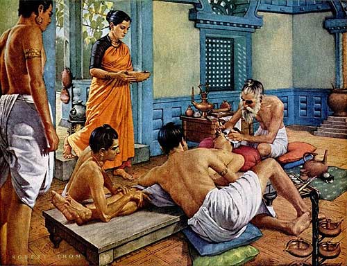
Maharshi Shushruta, The Great Grandfather of Surgery!
by Ayurvedacharya Dr.Hitesh Jani Dr.Hitesh Jani
-
- Tourism |
-
- Topics
- Travel
- Food&Beverages
- Hospitality
-
- Featured
-
“Keraliya Ayurveda is Credible and Authentic”
Irina Gurjeva Irina Gurjeva is not just another vacationer in..

-
- Sports |
- Editor's column |
- Magazine |
PhotoSat Completes Highly Accurate Satellite TSX-V: WZR Garmian Block in the Kurdistan Region of Iraq
Published on May 14, 2013
VANCOUVER, British Columbia : PhotoSat is pleased to announce that it has completed satellite topography mapping of WesternZagros’s Garmian Block in the Kurdistan Region of Iraq, using stereo satellite photos from the high-resolution Pleiades 1A and 1B imaging satellites. Pleiades 1A and 1B are the world’s newest 50cm resolution satellites. The satellite topography mapping consists of an elevation point every meter and contours with 1 meter elevation intervals. Based on comparisons between the satellite topographic mapping and thousands of ground survey points on similar projects, the accuracy of the satellite topographic mapping is expected to be about 30 centimeters. The topographic mapping and precision satellite ortho photos will be used for planning and execution of 3D seismic surveys, planning and construction of well sites and well site access roads, field development, and pipeline engineering studies.
“We are delighted to have the opportunity to apply our cutting-edge satellite topographic mapping technology and the world’s newest high resolution satellites to advance WesternZagros’s Garmian Block in the Kurdistan Region. Exploration and development success on the Garmian Block will provide significant economic benefits to WesternZagros shareholders as well as to the people of the Kurdistan Region,” says PhotoSat president Gerry Mitchell.