- News |
-
- Featured
-
Canada’s privacy commissioner launches investigation over the use..
As the years pass by, technology also widens, and more and more are being discovered. From simple gadgets..
- Business |
-
- Featured
-
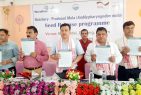
Be an informer to I-T dept; earn up..
Sharing "specific information" with the income tax department about any benami..
- Tech & Industry |
-
- Featured
-
Gravitational wave event likely signaled birth of black..
The merger of two neutron stars that generated gravitational waves detected last year may have led to the birth..

- Entertainment |
-
- Topics
- Malayalam Film
- Media
- Music
- Youth
-
- Featured
-
Shawn Mendes Released Highly Anticipated Self-Titled Album Today
Los Angeles, CA : Multi-Platinum singer/songwriter Shawn Mendes released his highly anticipated self-titled third album today, via Island Records. Get..

-
- New Products |
-
- Topics
- General
-
- Featured
-
ZOTAC Introduces Its GeForce GTX 960 series graphics..
Dubai- ZOTAC International, a leading innovator and manufacturer of graphic cards and mini-

-
- Education |
-
- Topics
- Campus News
-
- Featured
-
ITM University, Gurgaon Student Palash Chhabra Represents Varsity..
New Delhi: Palash Chhabra, a student of ITM University,..

-
- Health |
-
- Topics
- Medical News
-
- Featured
-
Maharshi Shushruta, The Great Grandfather of Surgery!
by Ayurvedacharya Dr.Hitesh Jani Dr.Hitesh Jani

-
- Tourism |
-
- Topics
- Travel
- Food&Beverages
- Hospitality
-
- Featured
-
“Keraliya Ayurveda is Credible and Authentic”
Irina Gurjeva Irina Gurjeva is not just another vacationer in..

-
- Sports |
- Editor's column |
- Magazine |
Arunachal High Alert For Tsangpo Barrier Lake Forms At Tsangpo After Landslide
Published on October 19, 2018
By Bhupen Goswami
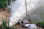
Guwahati : Aerial photo taken on Oct. 18, 2018 shows the barrier lake and landslide body in the Yarlung Tsangpo River in Menling County, southwest China’s Tibet Autonomous Region. More than 6,000 people have been evacuated after a barrier lake formed following a landslide in the Yarlung Tsangpo River in southwest China’s Tibet Autonomous Region, local authorities said Thursday. According to the local disaster relief headquarters, the landslide struck during the early hours of Wednesday near a village in Menling County, blocking the river’s  waterway. The amounts of water in the lake has surpassed 300 million cubic meters. No casualties have been reported. Authorities in Tibet have launched an emergency response, monitoring the lake’s water level, evacuating local residents and sending relief supplies to the disaster-hit areas. (Xinhua/Chogo)(sxk) 518 30 30 The East Sing district administration in Arunachal Pradesh has issued a high alert following apprehensions that a blockade in the Yarlung Tsangpo river in China caused due to an avalanche may burst any time causing sudden flash floods in the downstream areas along the Siang and Brahmaputra rivers that may cause massive cause loss to life and property. The East Siang district administration has cautioned the general public not to venture into the river or around its periphery as a preventive measure. Moreover, the district administration has directed the general public not to collect logs, trees, bamboo clams or any other vegetative materials from the banks of the river as it might serve as a Natural Flood Control Mechanism. The administration has warned that any violators would be charged under section 188 of the India Penal Code. Fast rising temperatures have caused those glaciers to melt at an increasing pace, throwing a shadow over future water resources for China and other Asian nations.At noon, the water level in the lake had risen 40 meters, and the amount of water reached 150 million cubic meters, the department said. Authorities in Tibet have launched an emergency response, calling for the safe evacuation of local residents. A work team has arrived at the site. More than 6,000 people were evacuated and more will follow after a barrier lake was formed following a landslide that blocked the Yarlung Tsangpo River in the Tibet autonomous region on Wednesday morning. Its water level continues to rise, local authorities said on Thursday. The landslide struck around 5 am on Wednesday near Gyalha village in Manling county, plugging the river that originates in Tibet and flows to India, according to the regional emergency response department. By 7 am on Thursday, the water level of the lake had risen to 59 meters, and the amount of water reached 360 million cubic meters. The water level had been rising at an average speed of about one meter an hour from midnight to 7 am, the department said around noon. More than 20,000 people in Manling and Medog counties were affected by the barrier lake and more people will be evacuated due to the risk of the barrier lake bursting. The regional government has activated the highest level of emergency response for geological disasters and evacuated 6,000 residents. The Ministry of Water Resources also required the regional government to provide hourly information of the water level of the Yarlung Tsangpo River at observation stations upstream and downstream of the barrier lake to Indian authorities. A 12-member local work team consisting of hydrological and geological experts had arrived at the site by Wednesday. A six-member team sent by the Ministry of Natural Resources arrived at Menling county around 8 am on Thursday, the regional emergency response department said. Wu Yingjie, Party chief of Tibet, urged the authorities to closely monitor the barrier lake and issue warnings on possible disasters. He also required them to evacuate residents who are threatened by the disaster. It was the region’s second major geological disaster less in a week. On Oct 11, the Jinsha River, in the upper reaches of the Yangtze River, was blocked by a landslide, creating a barrier lake in Chamdo. Water from upstream has burst through the blockade in the Jinsha River, causing the water level in the barrier lake to drop significantly, signaling an easing of risks for the lower reaches of the river. But the Ministry of Emergency Management warned on Saturday that the possibility of another landslide near the first landslide site has grown.